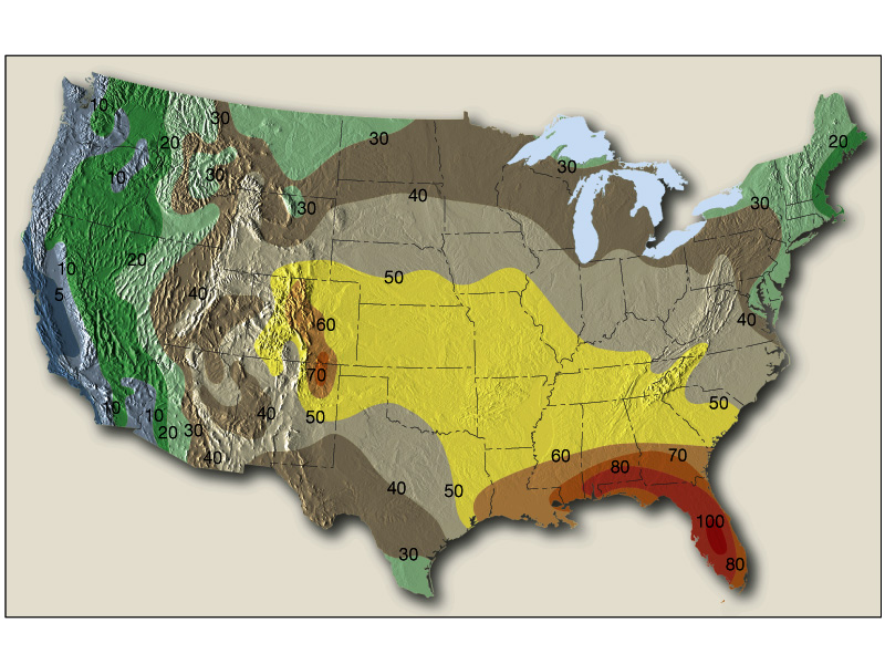
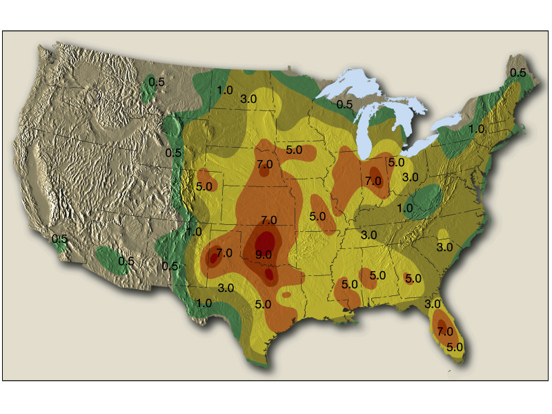
Thunderstorm frequency map for the United States
THUNDERSTORMS
SETTING THE STAGE
Thunderstorm frequency map for the United States
THUNDERSTORMS
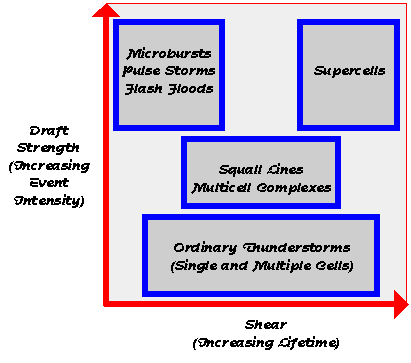
There are three types of thunderstorms:
Although the natural environment does not fall into three distinct categories,
we break them down to help illustrate significant differences. The differences
arise because of varying atmospheric profiles, especially those concerned
with vertical shear, defined as the change in wind velocity (speed or direction)
with height, or![]() .
.
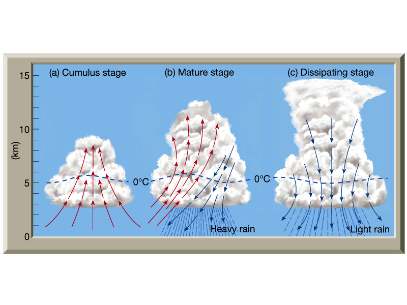
The air mass thunderstorm is a common and usually non severe phenomenon that forms away from frontal systems or other synoptic-scale disturbances. They form where moist and unstable conditions exist in the atmosphere. Air mass thunderstorms are usually produced in areas of very little vertical shear. As a result, the threat for severe is small. When they do reach severe limits, the thunderstorms may produce brief high winds or hail which develop because of high instability. These storms are know as pulse severe storms. Although several storm cells can develop, each individual cell lasts about 30-60 minutes and has three stages.
Cumulus Stage
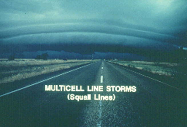
As wind shear organizes the convection, new thunderstorms form as a result of parent thunderstorm outflows converging with warm, moist inflow creating new updrafts. Multicell storms can form in a line known as a squall line, where continuous updrafts form along the leading edge of the outflow, or gust front. Multicell clusters indicate new updrafts are forming where the low-level convergence is strongest, usually at the right, or right-rear flank of existing cells.
Thunderstorms that organize in response to synoptic scale forcing usually need:
- warm, moist air at low levels
- cool, dry air at upper levels
- upper-level divergence (above 500mb)
- a synoptic scale disturbance
In these conditions, thunderstorm formation is probable. Synoptic scale vertical motions tend to create favorable conditions for thunderstorms, but thunderstorm initiation is usually a result of mesoscale forcing. Increasingly favorable vertical wind profiles may lead to a greater possibility of supercell development rather than multicell storms. The development of squall lines, or more commonly storm clusters, when thunderstorms do develop is virtually guaranteed in association with synoptic scale forcing.
Multicellular storms consist of a series of evolving cells. At low levels, cooler air diverging from the downdraft intersects the inflowing air along a gust front, creating a region of strong low- level convergence favorable for new updrafts. It is the presence of vertical wind shear that results in the "tilting" of the updraft and downdraft. Because of the tilting, the less buoyant downdraft air will not destroy the updraft and hence deprive itself up supersaturated updraft air. In any case, the movement of multicell storms systems is determined by combining the new cell development with the mean winds. Each individual cell typically moves with the mean winds, while new cells develop where the inflow meets the outflow, hence, in the region of strongest surface, or low-level, convergence.
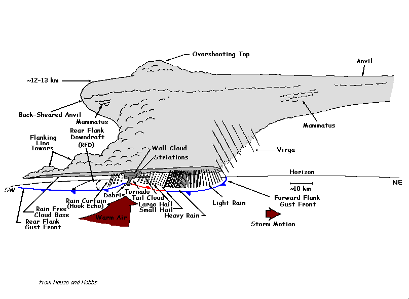
Supercells are the most powerful thunderstorms. By their definition, supercells are always severe. Supercells are responsible for a disproportionate amount of damage and casualties. The most significant difference arises from the presence of a rotating updraft, or mesocyclone. These features insure the longevity of a thunderstorm by allowing the flanking line to enhance the inflow into one main updraft, rather than helping create new updraft centers. The combination of rotation and longevity increase the chances for the development of strong or violent tornadoes.
Updrafts/Downdrafts
All thunderstorms require instability (potential) and lift. The lift is the mechanism that releases the instability. Lift is produced by such things as fronts and low pressure troughs, or by air rising upslope.
We say that the atmosphere is unstable when air rising in a cloud is warmer than its environment, like a hot-air balloon. It is the heat released by condensation within a cloud that permits the rising air to stay warmer than its surroundings, and thus to be buoyant through great depths.
In the same way, air that is cooler than its environment tends to sink as long as it can stay cooler than its surroundings. The upward moving air in a thunderstorm is known as the updraft, while downward moving air is the downdraft. The atmosphere can be unstable for updrafts but stable for downdrafts, stable for updrafts but unstable for downdrafts, stable for both, or unstable for both. The degree of atmospheric instability is one of the two major factors in determining the strengths of thunderstorm updrafts and downdrafts. Furthermore, vertical draft strengths basically determine the degree of storm severity. If we consider a "generic" storm, there are four possible combinations of weak and strong draft strengths.
When the low-level air is unstable but relatively dry and adequate mid-level moisture is present, a storm may develop with a weak updraft but a strong downdraft with the latter the result of strong negative buoyancy and cooling through evaporation of precipitation into the dry air. This high-based storm resembles high terrain, western U.S. storms which occasionally produce dry microbursts. Significant hail and rain are unlikely.
A storm which contains a strong updraft and weak downdraft; will not produce wind damage, but can foster heavy rains and/or damaging hail. Single and multicell storms comprise this category. They include storms that dump heavy rain, but little or no hail because of warm conditions aloft, and multicell storms that are capable of producing hail because of lower environmental freezing levels. Strong updraft, weak downdraft storms often form in very moist atmospheres where there is little, if any, dry air and evaporational cooling to drive downdrafts.
Relatively weak updrafts and downdrafts are found with non severe showers
and thunderstorms. The last possible combination is a storm with strong
updrafts and downdrafts. These storms frequently produce destructive downbursts,
hail, heavy rain, and tornadoes. As one would expect, the most severe storms,
including supercells, have strong vertical drafts and occur in the most
unstable atmospheres.
Single-Cell Storms
Dangers associated with Thunderstorms
Flash Floods and Hail
Cases involving either slow-moving thunderstorms or a series of storms
which move repeatedly across the same area (sometimes called train-echo
storms) frequently result in flash flooding. The total number of
flash flood deaths has exceeded tornado fatalities during the last several
decades.
Two factors seem to be responsible for this: public apathy regarding the flash flood threat and increased urbanization. When concrete replaces soil, rain water will run off rather than soak in. Flash flood producing rainfall has made this type of dramatic rescue attempt (pictured above) all too familiar, especially in urban areas and popular mountain camping spots.
Another danger associated with thunderstorms, especially to personal property, is hail. Hail causes more monetary loss than any other type of thunderstorm-spawned severe weather.
Annually, the United States alone suffers about one billion dollars
in crop damage from hail. Hail rarely kills people, but these were
hollow words in China in May, 1986 when 100 people were killed, 9,000 injured,
and 35,000 homes destroyed by an intense hailstorm.
Outflow - winds flowing outward from thunderstorms
Thunderstorm winds also cause widespread damage and occasional fatalities.
Thunderstorm "straight-line" winds originate from rain-cooled air that
descends with accompanying precipitation.
After the thunderstorm gust front passes and before precipitation, if any, arrives, blowing dust often is kicked up by thunderstorm induced winds. The amount of dust depends on soil type, soil moisture content, and wind intensity.
Severe thunderstorm winds are especially dangerous to aviation interests, particularly aircraft which are on final approach or taking off.
Many western US storms have extremely high bases and low tops. Don't let the weak appearance fool you! Some of the "dry storms" can produce dangerous microbursts and copious amounts of fire-setting lightning.
Recent research has shown that microbursts, both "dry" ones (actually some very light rain may fall with a dry microburst) and "wet" ones frequently are the cause of wind shear induced aircraft accidents.
Downburst - severe localized downdrafts
Damaging thunderstorm winds have been termed downbursts by renowned
severe storm researcher Dr. Ted Fujita. Dr. Fujita further classifies
these events as macrobursts (greater than 2.5 miles in diameter) and microbursts
(less than 2.5 miles in diameter).
Generally, a macroburst is on the scale of the entire cold air outflow field of a thunderstorm or a group of thunderstorms; whereas the microburst is a sub-thunderstorm scale outflow feature.
Tornadoes - violently rotating columns of air
The last severe weather element is the tornado. Defined as a
violently rotating column of air in contact with the ground and pendent
from a cumulonimbus cloud, tornadoes are capable of inflicting extreme
damage.
They can be categorized as "weak", "strong", and "violent"; with weak tornadoes often having a thin, rope-like appearance. About 7 in 10 tornadoes are weak, with rotating wind speeds no greater than about 110 MPH.
The typical strong tornado often has what is popularly considered a more "classic" funnel-shaped cloud associated with the whirling updraft. Rotating wind speeds vary from 110 to 200 MPH.
Nearly 3 in 10 tornadoes are strong. An important safety consideration is that weak and strong tornadoes, by definition, do not level well-built homes. Thus, a secure home will offer shelter from almost 100 percent of all direct tornado strikes.
Only violent tornadoes are capable of leveling a well-anchored, solidly constructed home. Fortunately, less than 2 percent of all tornadoes reach the 200+ MPH violent category. Furthermore, most violent tornadoes only produce home-leveling damage within a very small portion of their overall damage swath.
Tornado frequency map for the United States
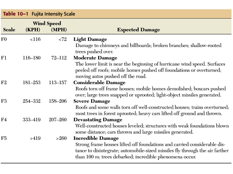
Fujita scale for tornado intensity.