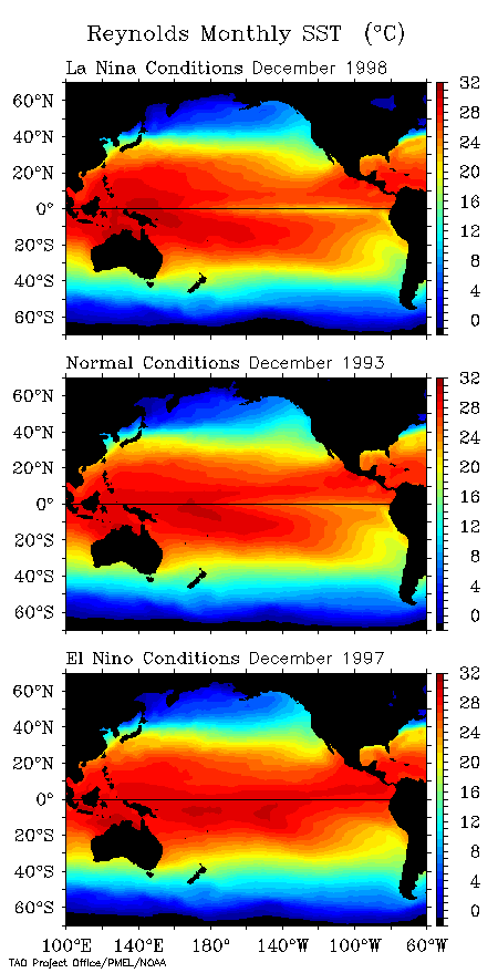
El Nino and La Nina
El Nino can be characterized by warmer than normal ocean temperatures in the Equatorial Pacific Ocean, whereas La Nina can be characterized by colder than normal ocean temperatures in the equatorial Pacific.
Not only can these fluctuations lead to changes in ocean temperatures, but the resulting changes in overlying air temperatures will change weather patterns and precipitation patterns.
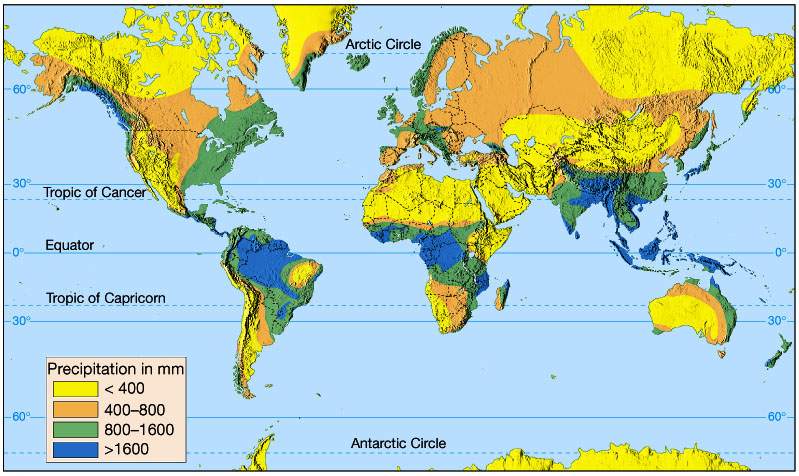
Mean annual precipitation, in millimeters.
Figure 7.24A in The Atmosphere, 8th edition, Lutgens and Tarbuck,
8th edition, 2001.
If we look at a cross-section of the Earth with atmospheric circulation and precipitation, we can see that the Hadley Cells, wind patterns, and ocean patterns all play a role in determining what regions are more habitable than others.
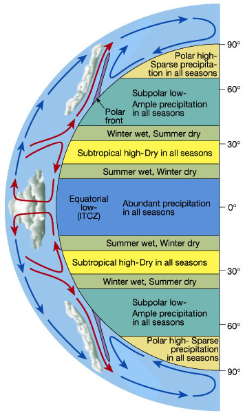
Idealized zonal precipitation patterns owing to atmospheric circulation.
If you'd notice, Charleston lies near the northern edge of the "Summer wet,
winter dry" zone.
But we know that Charleston weather isn't always like that.
Figure 7.25 in The Atmosphere, 8th edition, Lutgens and Tarbuck,
8th edition, 2001.
Since the weather, and climate in Charleston isn't exactly what we would expect from the idealized atmospheric circulation, we must somehow account for that.
Air Masses
An Air Mass is an immense body of air which is characterized by homogeneous physical properties (temperature & moisture) and can cover 1000s of square kilometers.
Classifications based on temperature:
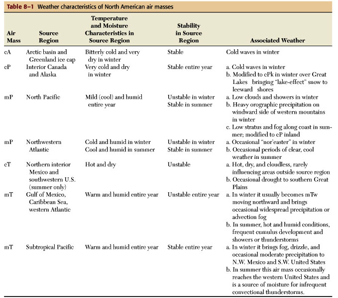
North American air masses and their characteristics.
Table 8.1 in The Atmosphere, 8th edition, Lutgens and Tarbuck, 8th
edition, 2001.
We can see the interaction of these various air masses
with our temperatures and precipitation, but we also need to take into account
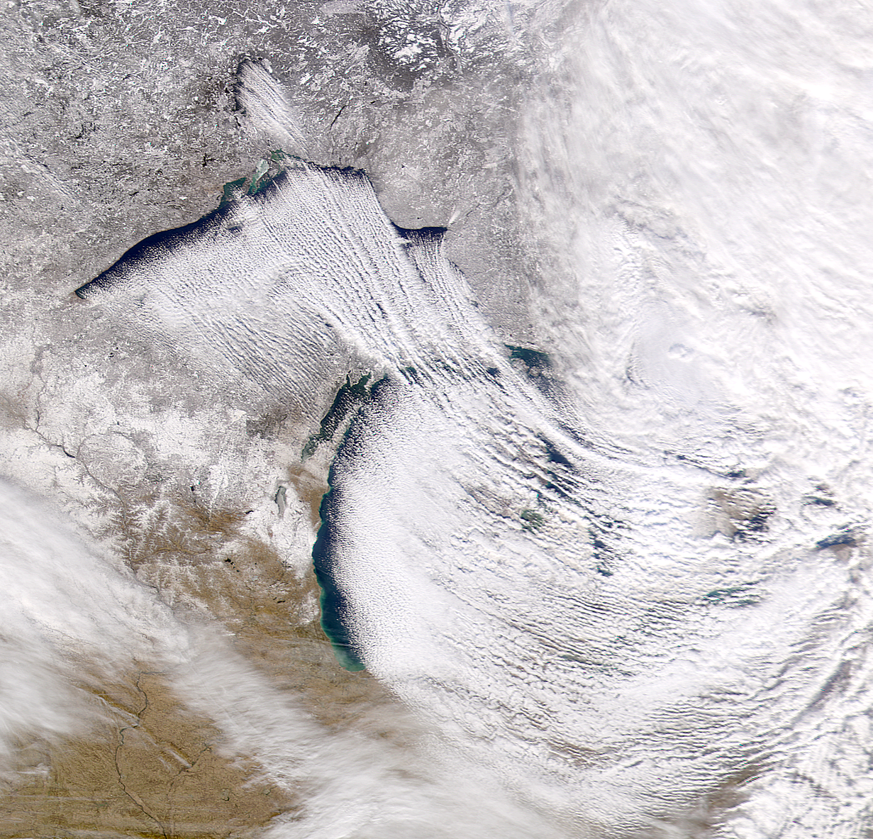
local variables. One such variable is proximity to large bodies of water.
Local bodies of water may intensify precipitation resulting in lake effect
snow if a cold front moves over them.
Below is a great example of lake effect snows - it is
a NOAA satellite image of lake effect snows on the Great Lakes.
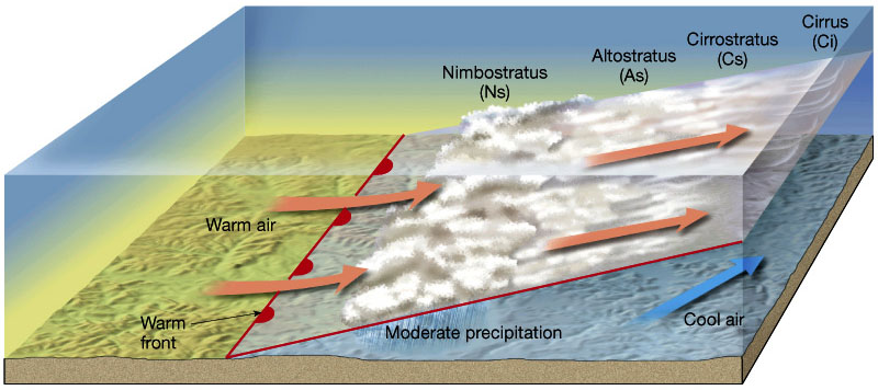
Now we can talk about where the air, and hence temperatures and moisture, is coming from. But how about air mass interactions? That's why we need to discuss fronts.
A weather front is a boundary that separates two air masses that have different densities. As two air masses collide they will mix along their boundary to some extent, but will for the most part retain their distinct characteristics.
There are five types of fronts which we need to know:
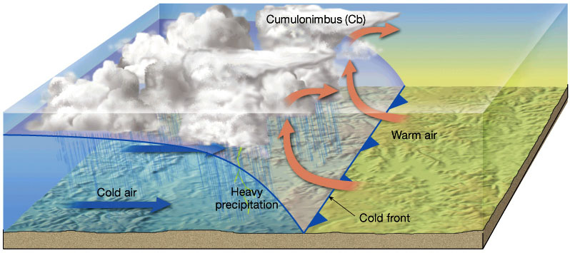
Warm Front is characterized by a warm (less dense) air mass moving into a cold air mass.
Stationary Front is characterized by a nearly stationary boundary between tow air masses.
Occluded Front is an active cold front which overtakes
a warmer front and is often associated with a variety of precipitation intensities
and duration. There are two types - depending on what type of air mass
overtook.
Formation of an occluded front.
Figure 9.8 in The Atmosphere, 8th edition, Lutgens and Tarbuck, 8th
edition, 2001.
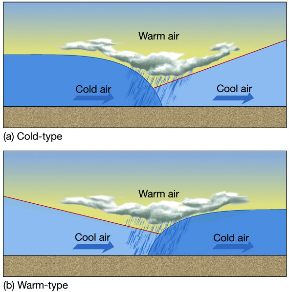
Formation of a cold-type (A) and warm-type of occluded fronts.
Figure 9.9 in The Atmosphere, 8th edition, Lutgens and Tarbuck, 8th
edition, 2001.
Drylines are a special type of front in which the temperature usually doesn't change, but humidity changes as the front moves through. Drylines are common over the southern Great Plains when dry, continental tropical air (cT) from the southwest meets maritime tropical (mT) from the Gulf of Mexico. The result is a squall line of intense thunderstorms and rain.
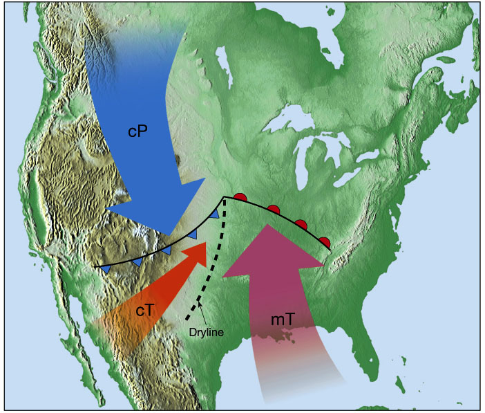
Schematic showing the development of a dryline as warm, dry air from the
desert southwest (cT) converges with warm moist air from the Gulf of Mexico
(mT).
The abrupt change in humidity identifies the dryline and the location of
the squall line of thunderstorms.
Figure 10.11 in The Atmosphere, 8th edition, Lutgens and Tarbuck,
8th edition, 2001.
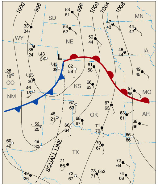
Surface weather map showing the development of a squall line. Note
the abrupt changes in humidity across the line (look at the dew points relative
to the temperatures).
Figure 10.12 in The Atmosphere, 8th edition, Lutgens and Tarbuck,
8th edition, 2001.
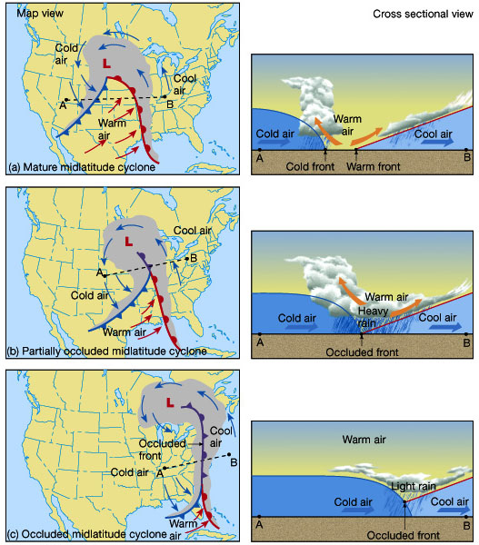
Midlatitude cyclones
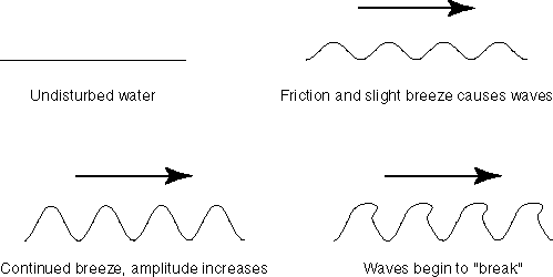
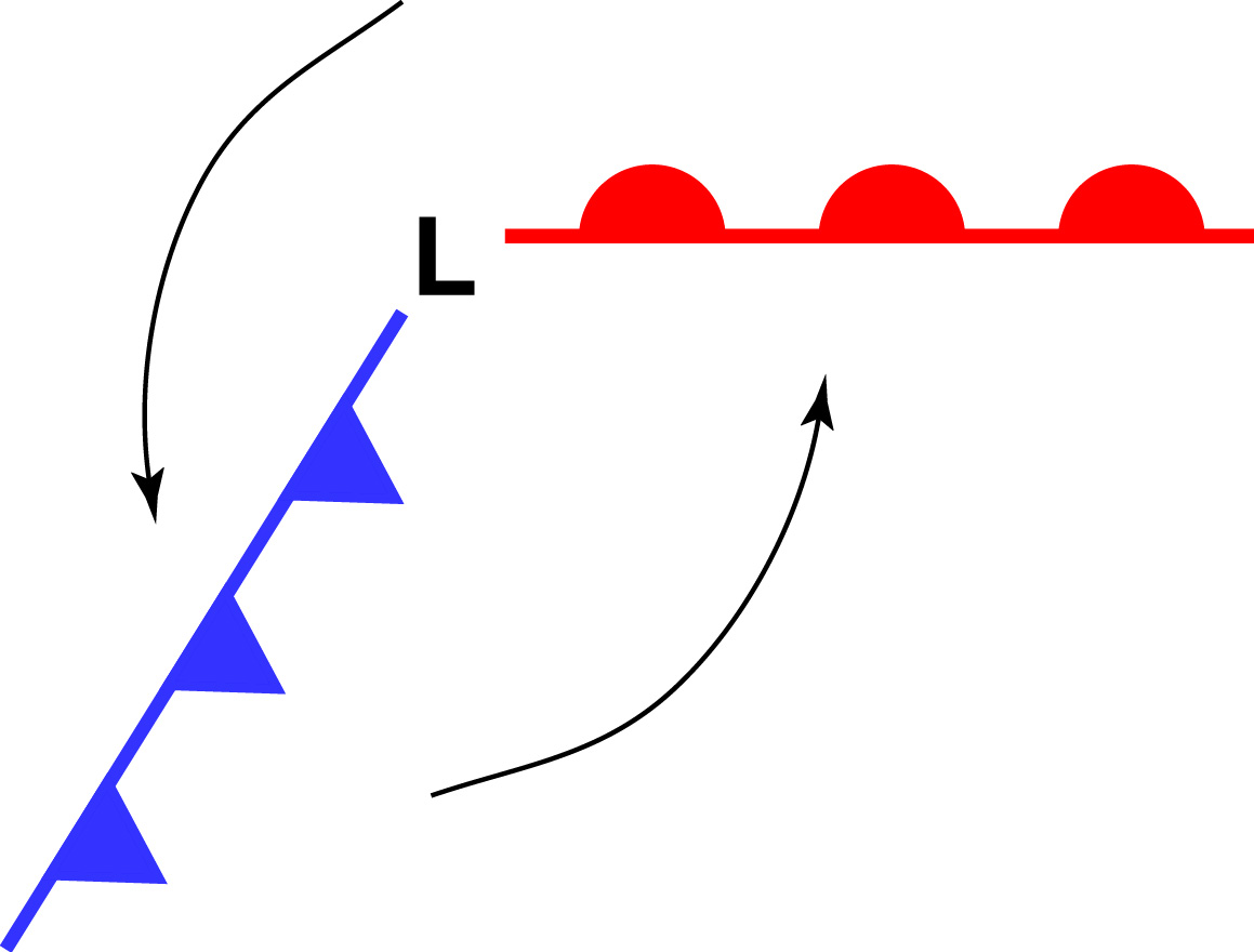
Since we are located south of the polar front and north of the horse latitudes, we are subject to the westerly winds. An analogy to midlatitude cyclone development is to think of wave development on water.
For the atmosphere, lets start out with two high pressure systems, one cP, one mT separated by an occluded front.
Winds associated with the maritime tropical air are blowing to the east
(they're westerlies), whereas winds associated with the continental polar
air are blowing to the west (they're easterlies).

As the winds continue to blow, the warm air is moving to the north and the cold to the south - trying to evenly distribute the thermal energy. Divergence aloft will remove more air than is replaced near the ground, resulting in a low pressure system (cyclone) forming.
With continued divergence aloft the low pressure system becomes stronger (deepens).
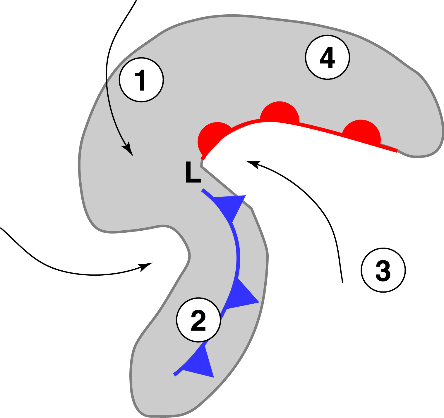
As the cyclone develops and deepens, a characteristic "comma" shape develops as well as the counterclockwise air flow. The comma shape is very useful in locating these cyclonic systems over the oceans.

Weather associated with different parts of the midlatitude cyclones
Weather around the midlatitude cyclone can be divided into the four sectors surrounding the low.