The Modified Mercalli Scale
of Earthquake Intensity
In seismology a scale of seismic intensity is a way of measuring
or rating the effects of an earthquake at different sites. The Modified
Mercalli Intensity Scale is commonly used in the United States by seismologists
seeking information on the severity of earthquake effects. Intensity ratings
are expressed as Roman numerals between I at the low end and XII
at the high end.
The Intensity Scale differs from the Richter
Magnitude Scale in that the effects of any one earthquake vary
greatly from place to place, so there may be many Intensity values
(e.g.: IV, VII) measured from one earthquake. Each earthquake,
on the other hand, should have just one Magnitude, although the
several methods of estimating it will yield slightly different values (e.g.:
6.1,
6.3).
Ratings of earthquake effects are based on the following relatively
subjective scale of descriptions:
Modified Mercalli Intensity Scale
from FEMA
I. People do not feel any Earth movement.
II. A few people might notice movement if they are at
rest and/or on the upper floors of tall buildings.
III. Many people indoors feel movement. Hanging objects
swing back and forth. People outdoors might not realize that an earthquake
is occurring.
IV. Most people indoors feel movement. Hanging objects
swing. Dishes, windows, and doors rattle. The earthquake feels like a heavy
truck hitting the walls. A few people outdoors may feel movement. Parked
cars rock.
V. Almost everyone feels movement. Sleeping people are
awakened. Doors swing open or close. Dishes are broken. Pictures on the
wall move. Small objects move or are turned over. Trees might shake. Liquids
might spill out of open containers.
VI. Everyone feels movement. People have trouble walking.
Objects fall from shelves. Pictures fall off walls. Furniture moves. Plaster
in walls might crack. Trees and bushes shake. Damage is slight in poorly
built buildings. No structural damage.
VII. People have difficulty standing. Drivers feel their
cars shaking. Some furniture breaks. Loose bricks fall from buildings.
Damage is slight to moderate in well-built buildings; considerable in poorly
built buildings.
VIII. Drivers have trouble steering. Houses that are
not bolted down might shift on their foundations. Tall structures such
as towers and chimneys might twist and fall. Well-built buildings suffer
slight damage. Poorly built structures suffer severe damage. Tree branches
break. Hillsides might crack if the ground is wet. Water levels in wells
might change.
IX. Well-built buildings suffer considerable damage.
Houses that are not bolted down move off their foundations. Some underground
pipes are broken. The ground cracks. Reservoirs suffer serious damage.
X. Most buildings and their foundations are destroyed.
Some bridges are destroyed. Dams are seriously damaged. Large landslides
occur. Water is thrown on the banks of canals, rivers, lakes. The ground
cracks in large areas. Railroad tracks are bent slightly.
XI. Most buildings collapse. Some bridges are destroyed.
Large cracks appear in the ground. Underground pipelines are destroyed.
Railroad tracks are badly bent.
XII. Almost everything is destroyed. Objects are thrown
into the air. The ground moves in waves or ripples. Large amounts of rock
may move.
As you can see from the list above, rating the Intensity of an earthquake's
effects does not require any instrumental measurements. Thus seismologists
can use newspaper accounts, diaries, and other historical records to make
intensity ratings of past earthquakes, for which there are no instrumental
recordings. Such research helps promote our understanding of the earthquake
history of a region, and estimate future hazards.
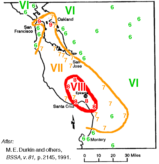
This map plots the Mercalli Intensity ratings of localities
near the Oct. 17, 1989 Loma Prieta (World Series) earthquake. It is called
an isoseismal map, as one draws contour lines to enclose locations
having higher intensities.
Intensities typically increase close
to an earthquake's epicenter, allowing seismologists to interpret maps
such as this for the general location of historical earthquakes.
Note the locations of unusually high intensities (up to IX) far
north of the earthquake's epicenter, near San Francisco Bay. During this
earthquake, soft and water-saturated soils near the Bay amplified the effects
of the shaking. The amplified shaking, together with soil liquefaction
effects, caused some well-built structures to collapse and yielded the
intensity IX rating at those locations.
It is also possible to estimate the Magnitude of an earthquake
from the area of the map enclosed by isoseismal contours of certain intensities.
Such estimates are, however, a subject of research and require verification.